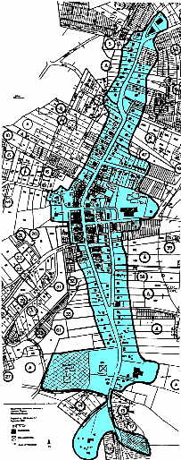
 A 95-acre area in the central downtown area of Chatham has been designated a Historic District. The area is bounded to the north at Hurt and College avenues, moves south along Main Street to end beyond Viccellio Road. It includes portions of Reid Street, Pruden Street and Lanier Avenue (map).
The process that led to the Historic District has provided the Town and its citizens resources to make informed comprehensive planning decisions that are sensitive to the historical significance of the 155 architectural structures in the district. State and Federal Tax Credits are available for rehabilitating and preserving the buildings in the National Register area.
In July 1999, the Virginia Department of Historic Resources (VDHR) entered into a cost-sharing agreement with the Town of Chatham to conduct a survey of architectural resources for approximately 155 structures in Chatham. In October 1999, Hill Studio, P.C. was contracted by the VDHR to conduct this survey. The survey project was carried out under the general direction of Alison Blanton, architectural historian and project manager. Mary Zirkle and Brandy Savarese of Hill Studio assisted in the documentation of the structures and the preparation of the survey report. Margaret Peters, director of the Cost-Share Program at VDHR in Richmond administered the project with the assistance of Dr. John Kern and Ms. Anne Beckett of the Roanoke Regional Preservation Office.
The final products of the survey project include: a survey report; an Integrated Preservation System (IPS) database for the survey area; site files; base maps; a National Register nomination for the historic district; and a scripted slide presentation suitable for use by local civic and school groups.
The survey report is available to the public at the Chatham Branch of the Pittsylvania County library. It includes an overview of the history of Chatham as represented by the historic resources in the survey areas as well as a thematic analysis of the surveyed structures as part of the National Register nomination. The survey report is intended to serve as a planning document for making sensitive land-use decisions and planning for future survey, evaluation, and treatment of the historic architectural resources within the area. The site files, photographs, and base maps prepared from the survey are part of the archival collection at VDHR in Richmond. Copies of these materials as well as the IPS database for the survey are located in the Town Office.